Navigraph have released a new update for their popular charts app which adds in the long requested feature of weather overlays.
Accompanying the update, the Swedish team also published a detailed blog post talking through the many helpful additions to Charts 8. For starters, when users open up Charts 8, they will now see a new button in the top left of their map view which opens the new weather overlay feature.

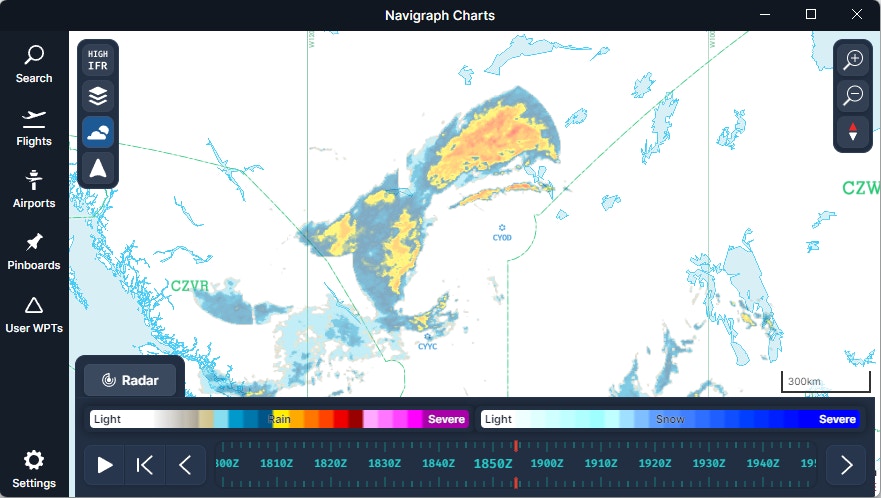
A bar will then appear along the bottom of the screen with ‘RADAR’ as the default setting. However, clicking on ‘RADAR’ will reveal a menu filled with new options.
The RADAR option itself shows a real time view of precipitation and storm activity, with the option to playback weather from up to 2 hours prior to real time, allowing users to guesstimate the weather conditions along their planned route as the flight progresses.
The AIRSIGMET / CWA tab displays areas of the map where potentially hazardous portions of sky can be expected. On my inspection, I was quickly able to see that thunderstorms up to flight level 420 (stop laughing) are forecast east of Paris this evening. Along with thunderstorms, the AIRSIGMET (AIRman’s METeorological Information / SIGnificant METeorological Information) also shows areas of potential turbulent air, icing, mountain obscuration, mountain waves (which I had never heard of before, they are apparently oscillations resulting from disturbances in airflow caused by mountains), and volcanic ash. Again, these AIRSIGMETs are kept up to date with real world conditions – fantastic for those of us who enjoy flying with live weather.


Moving on there is a METAR feature, which shows up to date METAR information for all airfields that report this information. In the submenu, there are also options to toggle temperature, dewpoint, visibility, ceiling, and wind information at every aerodrome on the map that is reporting. The cloud ceiling feature will be particularly useful for pilots who enjoy low-and-slow VFR flight.
After METAR, the next overlay is turbulence. You may recall this was already covered in the AIRSIGMET tab, although in that menu it is only shown as sections of airspace where turbulence has been reported or predicted. In this turbulence menu, the overlay instead depicts blobs where tubulence is likely based on current conditions. So, while it may not always be totally accurate, it does mean you can adjust your flight path accordingly should you wish to be extra cautious. The turbulence overlay also supports playback of up to six hours and predictions up to 32 hours ahead. In addition, there is also a toggle where you can select your desired flight level, allowing you to discount any conditions that might only exist above or below your planned route.


Next up there is a very similar menu for icing, which depicts the severity to be expected as blue patches, with darker blues correlating to more severe icing.
Then there is reflectivity, which as I understand it (although *disclaimer* I am not a meteorologist and might be wrong) is essentially another word for precipitation. It’s not as detailed as the radar view, although broadly the overlay shows reflectivity in the same areas where there is currently rainfall. This overlay also supports up to 6 hours of playback, and predicts up to 32 hours into the future.


Cloud cover and ISA temperature overlays are also available and like the turbulence menu have support for depicting cloud cover at various flight levels, with the user able to depict cloud cover/temperature along their route in increments of 4 flight levels starting at FL020 up to FL500. There is also support for playback and predictions in line with the timescales shown on other overlays.
Other overlays included in the update include those depicting wind barbs, the tropopause layer, the convective cloud top level, high cloud top level, visibility (and where it is reduced), MSL pressure, and jet streams.
The update is now available to all existing users of the Navigraph Charts App who hold a paid subscription to the service.
