We featured Working Title’s upcoming Garmin G1000 NXi yesterday and now we’re pleased to confirm that the freeware modification is now available to download.
The new modification will completely overhaul the default G1000 found in various default aircraft including the Cirrus SR22, Cessna 172 Skyhawk and the Beechcraft G36. After it’s installed, you will have access to a suite of features that truly enhance the simulation experience with the avionics unit.
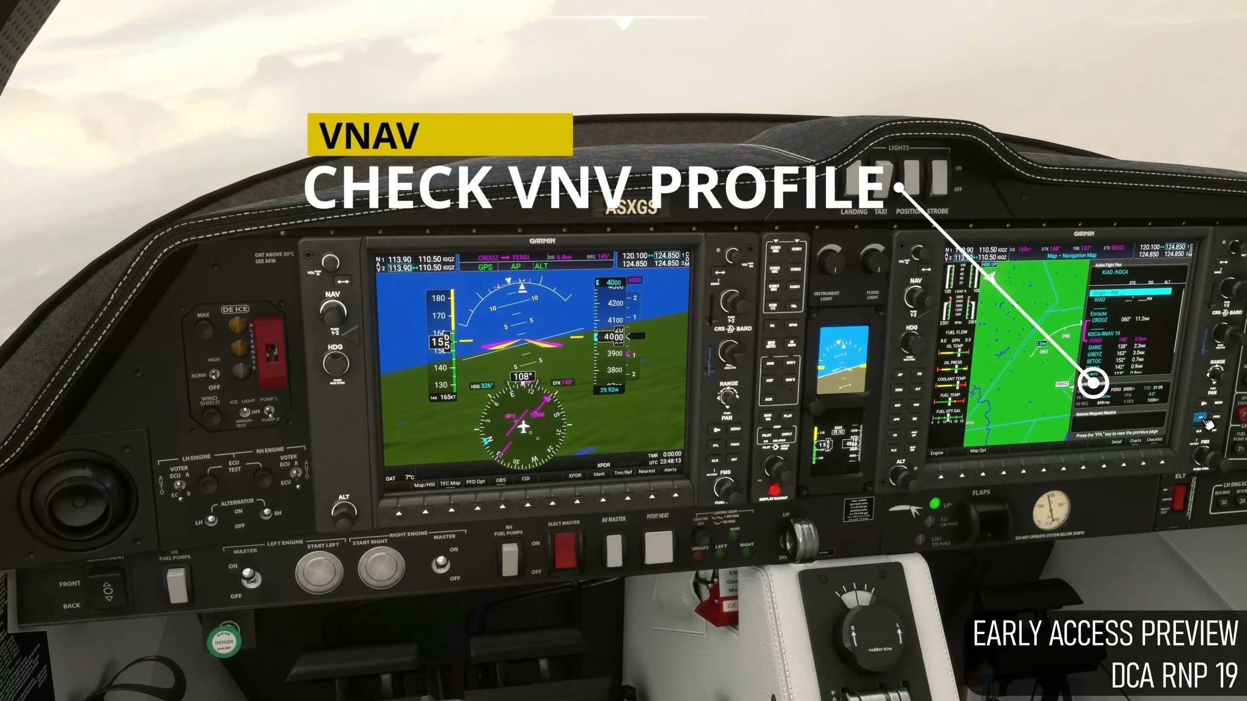
On the Working Title page, the team has broken down the key features into various sections. Starting with the navigation side of things, the G1000 NXi modification adds full real-time flight path vectorization and support of direct-to with proper matching behaviour. As we saw before, the VNAV has seen a huge improvement, also. Accuracy and guidance has been vastly improved, whilst full simulation of RNAV LPV approaches have now been implemented with the G1000 NXi unit. On the primary flight display, nearest airport functionality has been added as well as Baro minimums and all wind overlay modes. Finally, a new high-performance map system has been added, TOD and BOD marker placement and airspace rendering are all now part of the package.
You can watch a preview of the VNAV in action below.
The result of all these new features means that the G1000 is now much more realistic and in line with what pilots in the real-world use.
You can download the Garmin G1000 NXi for both the PC and Xbox versions of Microsoft Flight Simulator now through the in-sim Marketplace for free. It’s worth noting that it will be the only place you can download the modification and updates will be issued within the simulator. The freeware is in an early-access beta phase and the team intend on doing weekly or bi-weekly updates for the package.
Key features
Navigation
- Completely overhauled flight plan management system supporting all 23 ARINC 424 leg types
- New flyable leg types include RF, procedure turns, DME arcs, and more
- Full real time flight path vectorization and on-map visualization matching the real unit
- Full support of direct-to with proper matching behavior and waypoint sequencing
- Automatic and authentic NAV CDI scaling depending on flight phase (Departure, Terminal, APPR, LPV, etc.)
Accessibility
- Inputting waypoints can be done by keyboard by clicking the input field, and exited from keyboard mode by clicking anywhere else
Vertical Navigation:
- Full VNAV path navigation simulation with correct VPTH arm and active behavior
- Correct vertical deviation indications for VNV active profile deviation, GP, and GS
- Accurate VNAV path calculation from vectorized plan includes path guidance through turns and arcs
- Provides vertical guidance from loaded procedures such as departures, arrivals, approaches
- Full simulation of RNAV LPV approaches including angular distance CDI scaling
- Glideslope/Glidepath preview to easily transition from VNAV descent into approach.
PFD:
- Selectable between artificial horizon and synthetic vision
- Avilable inset or HSI map
- All wind overlay modes
- HSI may be set to layout in standard or HSI map modes
- V-speed bugs pulled from aircraft cfg data
- Timer/Ref page with count-up/countdown timer and V-Speed input
- Baro minimums
- Bearing pointers
- Nearest airports (Allows easy direct-to and radio tuning capabilities)
- Select HPA or IN for altimeter units
- Standard BARO option
MFD:
- Improved engine instrument displays (Still WIP)
- Active VNV Profile pane on MFD flight plan page with realtime updates
- Waypoint Info page with map layer to visualize fix before selection
Flight Plan Screens
- Full support for waypoint input with available waypoint details
- Procedure selection with accurate leg parsing and waypoint deduplication
- Flight plan menu with ability to activate leg, delet plan, invert plan, and remove procedures
Mapping:
- Entirely revamped high performance map system
- Authentic collision based waypoint label culling system for auto-declutter
- Brand new waypoint, navigation fix, and airport icons
- Highly accurate TOD and BOD marker placement
- Airspace rendering
Nav Radios
- Automatically identifies localizers and VORs when tuned in.
